Forecasters Predict Up to 18 Inches of Snow as Nor'easter HitsStaff Reports,
03:22PM / Monday, February 01, 2021 | |
A nor'easter is expected to dump upwards of a foot of snow across the region beginning Monday afternoon. Check iBerkshires for updates closures, cancellations and notices on this article and on our Facebook page.
The National Weather Service in Albany, N.Y., issued a winter storm watch from Monday at 7 a.m. through Tuesday at 7 p.m.
The town of Adams had declared a winter storm emergency: no parking on town streets or in municipal lots from 3 p.m. Monday through 5 p.m. Tuesday. Any vehicles unatt3ended my be towed.
The town of Lenox had declared a winter storm emergency from 4 p.m. Monday through 8 p.m. Tuesday. No parking on streets and violators may be towed.
Many schools are already in remote learning. For those in hybrid or in-class learning:
• Central Berkshire and Hoosac Valley regional schools will be fully remote Monday and Tuesday as w
• Early dismissal Monday: Berkshire Hills Regional, Clarksburg, Emma Miller, Gabriel Abbott, Lee Public Schools, Lenox Public Schools (high school remote all day), Richmond Consolidated, and Stamford.
• Mount Greylock Regional is releasing from classes at 11 a.m.; Tuesday is a traditional snow day
Cancellations and closures:
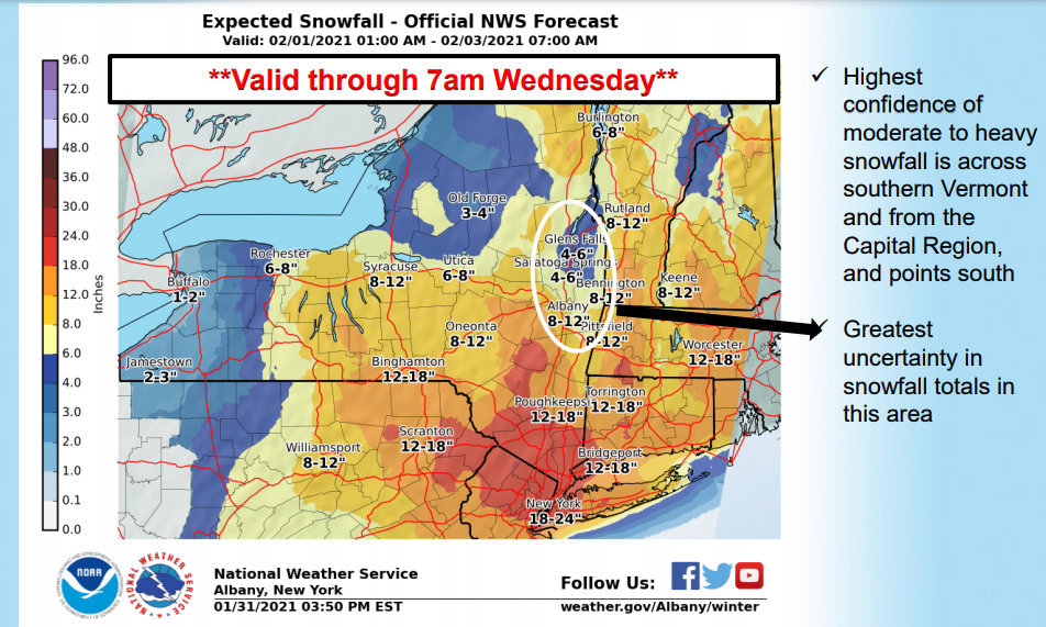
Anywhere from 8 to 18 inches of snow is expected over the Berkshires with winds as high as 35 mph. Snowfall rates of an inch an hour are possible from Monday afternoon into Tuesday, with lighter snow showers through the day on Tuesday.
Heavy snowfall, blowing and drifting will affect visibility and make driving hazardous. Anyone who has to travel should keep an extra flashlight, food, and water, and blanket in your vehicle in case of an emergency.
State officials are urging residents to stay off roadways and to use public transportation when possible as the storm moves across the commonwealth by mid-day Monday. Nonessential workers in the executive branch are asked to stay home and Registry of Motor Vehicles branches will close at noon.
Individuals unable to get to their vaccination sites will be contacted and have their appointments rescheduled.
The state Department of Transportation has approximately 3,900 pieces of state and vendor equipment available for snow and ice operations and this includes over 1,400 plow and spreader combos, 2,100 plows, and 460 front-end loaders.
MassDOT is anticipating a tractor-trailer ban from 10 a.m. to midnight on the MassPike and dropping the speed limit to 40 mph.
The nor'easter is the result of two storm systems that will spread snow and ice across the Midwest and into the Northeast.
"The coastal storm will then become the dominant storm of the two, strengthening into a full-blown nor'easter along the Atlantic coast."
Accuweather meteorologists expect widespread snowfall totals of 12-18 inches where the heaviest snow falls. A bullseye of nearly 2 feet could target a small area just north and west of New York City, into the Pocono and Catskill mountains. Boston could see 6-12 inches and New York City 10-15.
| 
 MEMBER SIGN IN